Loading...
Toussaint Louverture vs Trajan
Toussaint Louverture leads by 2.5 pts · 2 figures compared
…
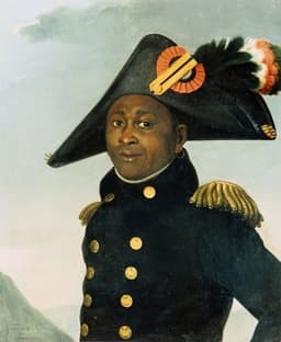
Toussaint Louverture
General · Modern
78.5Total

Trajan
Emperor · Ancient
76.0Total
Basic Information
Born
1743
53
Died
1803
117
Era
Modern
Ancient
Nationality
Haiti
Roman Empire
Occupation
General
Emperor
Civilization
Western
Western
Score Comparison
Military (10%)
85.0
86.0
Political (20%)
70.3
79.2
Influence (20%)
84.0
82.0
Legacy (20%)
82.0
65.6
Leadership (15%)
72.0
73.2
Strategy (15%)
72.0
76.0
TOTAL
78.5
76.0
Toussaint Louverture — Complete Timeline
1791 AD
Haitian Revolution LeadershipWar
Louverture joined the slave revolt in Saint-Domingue, quickly rising to leadership. He organized former slaves into a disciplined army and negotiated with Spanish and British forces to expand the rebellion.
Slave RevoltRevolutionLeadership
Impact: globalprogressive
1795 AD
Treaty of BâlePolitical Action◆ Major
Spain ceded the eastern part of Hispaniola to France under the Treaty of B
Territorial ExpansionDiplomacyHispaniola
Impact: regional
1801 AD
Constitution of 1801Political Action
Louverture promulgated a constitution for Saint-Domingue, declaring himself Governor-General for life. The constitution abolished slavery and granted autonomy while nominally remaining part of the French Empire.
ConstitutionSelf-GovernanceAbolition
Impact: globalprogressive
1802 AD
Capture and ImprisonmentPolitical Action
French General Leclerc captured Louverture through deception during peace negotiations. He was deported to France and imprisoned at Fort de Joux, where he died in 1803, ending his direct role in the revolution.
BetrayalImprisonmentFrench Repression
Impact: globaltragic
Trajan — Complete Timeline
101 AD
Implemented the Alimenta Welfare ProgramReform◆ Major
Trajan expanded the Alimenta program, a state-funded welfare system that provided food subsidies and educational support for poor children in Italy. The program used interest from state loans to landowners to fund the distributions, aiming to boost the Italian population and agricultural economy.
WelfareSocial PolicyItaly
Impact: regionalconstructive
105 AD
Built Trajan's Bridge over the DanubeOther
Trajan ordered the construction of a massive stone and timber bridge across the Danube River near the Iron Gates. Designed by Apollodorus of Damascus, it was the longest arch bridge in the world for over a millennium, facilitating the Roman invasion of Dacia.
EngineeringBridgeDanube
Impact: regionalconstructive
106 AD
Conquered DaciaWar
Trajan led two major campaigns against the Dacian kingdom under King Decebalus, culminating in the conquest of Dacia (modern Romania) in 106 CE. The victory brought vast gold and silver mines under Roman control and established a new province, funding massive building projects in Rome.
DaciaConquestProvince
Impact: regional
112 AD
Built Trajan's Forum and MarketCultural◆ Major
Trajan commissioned the construction of Trajan's Forum, a vast complex in Rome including a basilica, libraries, and the Column of Trajan. The adjacent Trajan's Market, a multi-level commercial center, demonstrated Roman engineering prowess and served as a model for urban planning.
ArchitectureRomeUrban Planning
Impact: globalconstructive
116 AD
Conquered Parthia and Reached the Persian GulfWar◆ Major
Trajan launched a campaign against the Parthian Empire, capturing its capital Ctesiphon and annexing Mesopotamia. He reached the Persian Gulf, marking the easternmost extent of Roman territory. However, rebellions in the conquered territories forced a withdrawal shortly after.
ParthiaMesopotamiaExpansion
Impact: global
Expert Analysis
Origins
Toussaint Louverture (1743-1803) was born into slavery on a Haitian plantation, but gained freedom in his 30s. Self-educated, he absorbed Enlightenment ideals and military tactics. Trajan (53-117 CE) was born in Italica, Spain, into a patrician family. His father was a senator and governor, providing Trajan with a privileged upbringing and a military career from youth.
Rise to Power
Louverture emerged as a leader during the 1791 slave revolt. He allied with the Spanish against the French, then switched sides when the French abolished slavery. By 1798, he controlled Saint-Domingue, outmaneuvering rivals like André Rigaud. His diplomatic skill secured the Treaty of Bâle in 1795, ceding Spanish Santo Domingo. Trajan rose under Emperor Domitian, serving as consul and commander. After Domitian's assassination, the aging Nerva adopted Trajan as his heir, ensuring a smooth transition in 98 CE. Trajan's popularity with the army secured his position.
Leadership & Governance
Louverture governed Saint-Domingue with a mix of military discipline and economic pragmatism. He restored the plantation system using paid labor, maintained trade with Britain and the US, and promulgated the Constitution of 1801, which made him governor-for-life and abolished slavery permanently. He centralized power but allowed local autonomy. Trajan was a hands-on administrator, known for his extensive building projects (Trajan's Forum, markets, aqueducts), the Alimenta welfare program for orphans, and legal reforms. He expanded the empire to its greatest extent, but his governance was authoritarian, with the Senate reduced to a rubber-stamp body.
Triumph & Tragedy
Louverture's triumph was defeating French, Spanish, and British forces, and establishing a self-governing Black state. His tragedy came when Napoleon Bonaparte sent a massive expedition in 1802. Tricked into a meeting, Louverture was captured and deported to France, where he died in prison in 1803. His lieutenants, including Jean-Jacques Dessalines, continued the revolution and won independence. Trajan's triumph was the Dacian Wars (101-106 CE), which brought immense wealth and the province of Dacia. His Parthian campaign (113-117) captured the Parthian capital and reached the Persian Gulf. Tragedy struck when he fell ill and died in 117 CE, leaving the empire overextended and his successor Hadrian to abandon Trajan's eastern conquests.
Character & Destiny
Louverture was cunning, disciplined, and charismatic, with a vision of racial equality. He believed in education and order, but his trust in French promises proved fatal. His destiny was to inspire the only successful slave revolt, but he did not live to see Haiti's independence. Trajan was pragmatic, ambitious, and beloved by soldiers. He was known for his simple lifestyle and justice, but his expansionist drive strained the empire's resources. His destiny was to be remembered as the "best emperor" by the Senate, though his conquests were soon reversed.
Legacy
Louverture's legacy is immense: he shattered the myth of Black inferiority and inspired anti-colonial movements worldwide. However, Haiti's post-independence struggles (isolation, debt, political instability) partly reflect the destruction wrought by the revolution. Trajan's legacy includes architectural marvels (Trajan's Column), legal precedents, and the peak of Roman territorial extent. Yet his conquests were expensive and unsustainable. Both are celebrated but with caveats: Louverture as a freedom fighter, Trajan as a model emperor. Numerical scores: Louverture: Military 85, Political 70, Influence 84, Leadership 82, Discipline 72, Strategy 72, Toughness 78. Trajan: Military 86, Political 79, Influence 82, Leadership 66, Discipline 73, Strategy 76, Toughness 76.
Conclusion
On balance, Toussaint Louverture is the greater historical figure. While Trajan expanded an already powerful empire, Louverture achieved the impossible: leading enslaved people to defeat major European powers and establish a free state. His impact on global history—as a symbol of resistance and racial equality—transcends Trajan's territorial gains. Trajan's military and administrative achievements are impressive, but Louverture's moral and revolutionary significance gives him a higher overall score. The score gap of 2.5 points reflects this: Louverture's leadership and influence outweigh Trajan's military prowess and political skill.
Rankings
🥇
Toussaint LouvertureLeader
Mil: 85.0Pol: 70.3Inf: 84.0
78.5
🥈
Trajan
Mil: 86.0Pol: 79.2Inf: 82.0
76.0
+2.5 behind
How This Comparison Works
Algorithm
Each figure is scored on 6 dimensions (0—100 scale) based on structured historical data: Military (10%), Political (20%), Influence (20%), Legacy (20%), Leadership (15%), Strategy (15%). The weighted total produces the final ranking.
Data Sources
Scores are computed from structured sub-indicators in the database. Scale factors adjust for era (Ancient ×0.85, Modern ×1.0) and civilization size (Eastern ×1.05, Other ×0.80) to account for differences in population and military scale.
Maximum 3 Figures
Comparisons are limited to 2—3 figures to ensure readability and statistical meaningfulness.
Error Margins
±5 points per dimension — Sub-scores are derived from historical records with inherent uncertainty. Two figures within 5 points on a dimension should be considered roughly equivalent in that area.
Total Score Accuracy
±3 points overall — The weighted combination of 6 dimensions produces a total score with approximately ±3 points of uncertainty. Differences of less than 3 points are not statistically significant— the figures are effectively tied.
Known Limitations
- Historical records are incomplete and uneven across civilizations
- Figures from oral-tradition societies may be underrepresented
- Occupation labels can misclassify multi-role figures
- Scores measure capability and impact, not moral character
- Quantitative scoring is a comparison tool, not absolute truth
Capability Radar
Military (10%) — Battles & Warfare
Battles
85
95
Win Rate
80
98
Expansion
70
95
Political (20%) — Governance & Reform
Reform
85
88
Diplomacy
80
85
Economy
60
90
Influence (20%) — Cultural & Global Reach
Cultural
85
85
Global
85
85
Legacy (20%) — Historical Impact
Historical
95
90
Longevity
90
88
Leadership (15%) — Power & Stability
Tenure
65
90
Stability
55
92
Strategy (15%) — Tactics & Innovation
Strategy
85
92
Tactics
90
88
Reform
75
85
Similar Comparisons
Comments & Discussion
No comments yet. Be the first to share your thoughts!