Loading...
This comparison has not been analyzed yet.
One-time AI generation (~1 minute). Scores and timeline are already available below.
Abi-Eshuh vs Manishtushu
Manishtushu leads by 6.3 pts · 2 figures compared
…

Abi-Eshuh
Emperor · Ancient
34.6Total
Manishtushu
Emperor · Ancient
40.9Total
Basic Information
Born
-1711
-2269
Died
-1684
-2255
Era
Ancient
Ancient
Nationality
Babylon
Akkadian Empire
Occupation
Emperor
Emperor
Civilization
Middle Eastern
Middle Eastern
Score Comparison
Military (10%)
22.6
38.3
Political (20%)
29.3
36.5
Influence (20%)
42.4
47.1
Legacy (20%)
32.5
36.7
Leadership (15%)
41.5
45.0
Strategy (15%)
30.3
38.6
TOTAL
34.6
40.9
Abi-Eshuh — Complete Timeline
1700 BC
Construction of Dams against the SealandPolitical Action◆ Major
Abi-Eshuh ordered the construction of dams and canals along the Tigris River to control flooding and to cut off water supply to the Sealand region, a rebellious area in southern Mesopotamia. This hydraulic engineering project aimed to weaken the Sealand rebels by depriving them of irrigation.
Hydraulic EngineeringSealandRebellion
Impact: regional
Manishtushu — Complete Timeline
2269 BC
Trade Expedition to Magan and MeluhhaCultural◆ Major
Manishtushu, king of the Akkadian Empire, sent a trade expedition to Magan (Oman) and Meluhha (Indus Valley). Inscriptions record the acquisition of diorite stone for statues and other goods. This trade network connected Mesopotamia with distant regions, demonstrating the empire's reach.
TradeMaganMeluhha
Impact: globalconstructive
2265 BC
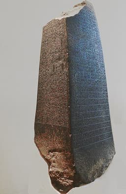
Construction of the Manishtushu ObeliskCultural
Manishtushu erected a large diorite obelisk recording land purchases in the city of Kish. The obelisk lists the fields bought, their prices, and the names of the sellers. It is a key source for understanding land ownership and economic practices in the Akkadian period.
ObeliskLand PurchaseKish
Impact: regional
2260 BC
Campaign against the LullubiWar
Manishtushu led a military campaign against the Lullubi, a mountain people in the Zagros. He defeated them and erected a victory stele. This campaign secured the northeastern frontier of the Akkadian Empire and is recorded in inscriptions found at Susa.
Military CampaignLullubiZagros
Impact: regional
This comparison has not been analyzed yet.
One-time AI generation (~1 minute). Scores and timeline are already available below.
Rankings
🥇
ManishtushuLeader
Mil: 38.3Pol: 36.5Inf: 47.1
40.9
🥈
Abi-Eshuh
Mil: 22.6Pol: 29.3Inf: 42.4
34.6
+6.3 behind
How This Comparison Works
Algorithm
Each figure is scored on 6 dimensions (0—100 scale) based on structured historical data: Military (10%), Political (20%), Influence (20%), Legacy (20%), Leadership (15%), Strategy (15%). The weighted total produces the final ranking.
Data Sources
Scores are computed from structured sub-indicators in the database. Scale factors adjust for era (Ancient ×0.85, Modern ×1.0) and civilization size (Eastern ×1.05, Other ×0.80) to account for differences in population and military scale.
Maximum 3 Figures
Comparisons are limited to 2—3 figures to ensure readability and statistical meaningfulness.
Error Margins
±5 points per dimension — Sub-scores are derived from historical records with inherent uncertainty. Two figures within 5 points on a dimension should be considered roughly equivalent in that area.
Total Score Accuracy
±3 points overall — The weighted combination of 6 dimensions produces a total score with approximately ±3 points of uncertainty. Differences of less than 3 points are not statistically significant— the figures are effectively tied.
Known Limitations
- Historical records are incomplete and uneven across civilizations
- Figures from oral-tradition societies may be underrepresented
- Occupation labels can misclassify multi-role figures
- Scores measure capability and impact, not moral character
- Quantitative scoring is a comparison tool, not absolute truth
Capability Radar
Military (10%) — Battles & Warfare
Battles
10
25
Win Rate
10
30
Expansion
5
35
Political (20%) — Governance & Reform
Reform
15
20
Diplomacy
10
35
Economy
15
40
Influence (20%) — Cultural & Global Reach
Cultural
5
20
Global
5
20
Legacy (20%) — Historical Impact
Historical
10
25
Longevity
5
15
Leadership (15%) — Power & Stability
Tenure
30
30
Stability
20
25
Strategy (15%) — Tactics & Innovation
Strategy
20
25
Tactics
15
20
Reform
5
15
Similar Comparisons
Comments & Discussion
No comments yet. Be the first to share your thoughts!